Wreck Beach Foreshore West (Acadia Beach)
Vancouver, British Columbia, Canada
 Passed tests Wed, Jun 10, 2026 at 6:20pm
 5.2°C / 41.4°F (air) Wed, Jun 10, 2026 at 1:45am
 12.6 - 26.4km/h W 260° Wed, Jun 10, 2026 at 1:45am
 Clear Wed, Jun 10, 2026 at 1:45am
 0mm Wed, Jun 10, 2026 at 1:45am
 2km Wed, Jun 10, 2026 at 1:45am
 89% Wed, Jun 10, 2026 at 1:45am

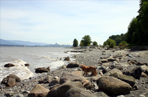
Acadia Beach is located between Spanish Banks and Wreck Beach on the northwest tip of the University of British Columbia.
From the parking lot there is an easy trail leading down to the beach. This beach ranges from sandy to rocky with lots of logs. There are a few places where you have to scramble over the logs. This terrain makes Acadia Beach less popular with sunbathers and perfect for walking along. There are quite a few nice spots to explore tidal pools and take photos.
There is no official trail on the beach, however by wandering west you will reach Tower Beach which is marked by two WWII Watch Towers built to look for Japanese submarines. Beyond Tower Beach lies Wreck Beach, Vancouver's only official nude beach.
There are several paths leading up from the beach to the top of the bluffs. Trail #4 actually comes out behind the UBC Museum of Anthropology. Walking back to the parking lot along the bluffs has some great views of Georgia Strait and the opening of Burrard Inlet.
Directions
The parking lot is just off of NW Marine Drive on the north side of the road. Parking lot gates are supposedly closed between 5 pm and 8 am.
First Nations History
Wreck Beach Foreshore West (Acadia Beach) is located on the traditional, ancestral, and unceded territory of the Musqueam First Nation. The Musqueam have lived on this land since time immemorial. This area was known as “Ulksen” or “the nose” as it described the shape of the extending portion of the peninsula. The land and waters here have always been a place of knowledge for the Musqueam, where they would educate and train their youth. The sea was used for canoe pulling and fishing, the forest for hunting and gathering, and the beaches for crabbing.
The Point Grey cliffs acted as a place of defense. The Musqueam had specially selected people who were called “runners” that would stand guard on these tall cliffs. They would be on the lookout for incoming invaders from the north, particularly the Squamish and the Haida of Vancouver Island and the Queen Charlotte Islands. The runners would have to decide if these incomers were friends or enemies, and would sprint through trails in the forests to alert their tribal members. If the incomers were deemed to be enemies, the Musqueam defense would counter the aggressor by embarking war canoes and warding off the invasion.
The description above was copied from or heavily based on Swim Guide, with permission.
Features
- The beach is sandy
- The beach is rocky
- Public Parking
- Pet Friendly
- Public Restrooms
- Disabled friendly
- Walking Trails
More Information
- Acadia Beach on Sandee
- Swim Guide - Weather and water quality for Wreck Beach Foreshore West (Acadia Beach) and 8,000 other beaches.
- Wikipedia
- Google Maps